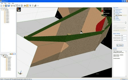
Using VisLog, the user will be able to enter borehole information make a 3-dimensional interactive view of the subsurface layers. Input data can be entered manually or imported directly from gINT. The 3D model can then be exported to PDF, image formats and movie format which are easily viewable by the clients and can be attached to geotechnical reports.
With intelligent engine of VisLog, generating soil profiles between boreholes is as easy as 1-2-3. VisLog can even be used for ground improvement projects to visualize the results. The developers of VisLog have presented a paper in GeoHalifax conference (2009) regarding a ground improvement project in Canada which was processed using VisLog.
Comments